Buléon

Son patrimoine

a_1
 :

Sponsor

buleon
<Cliquez l'image>

■ Buléon: Patrimoine

Le patrimoine de 
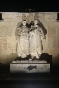
Buléon mérite intérêt et visite. Qu'il soit petit ou grandiose patrimoine, il témoigne de la vie locale passée et présente.

Ce patrimoine est, peut-être et aussi, un patrimoine naturel, des paysages, une foule de petits détails, un linteau de porte ou une sculpture de porte ou autres. Vous saurez les apprécier si vous les regardez avec un œil curieux ; ils sont aussi témoignage d'un riche passé que nous offrent nos ascendants.

Sachez profiter de ce don remarquable !

Merci à wikipédia et autres d'arrêter de plagier nos textes et travaux


Buléon

buleon

  • FrançaisBuléon
  • BrezhonegBuelion
    ( Breton )
  • Population546
    GentiléBuléonnais
  • Superficie12,27 km²
  • Densité44.5 /km²
  • Latitude47° 56 '2" N°
    Longitude2° 41 '33" W°
  • Latitude47.933934°
    Longitude-2.675754°
  • Buléon17 pages


Rue Bric et Brac

⌘ Buléon: Son patrimoine

Calvaire chez Gratien
◎ Calvaire chez Gratien -
Lat: 47.631617° - Long: : -2.281716° - Chez Gratien - Croix ou Calvaire XIX° - Sur la fourche ⤇ 

Chapelle de la Ville-ès-Cars
◎ Chapelle de la Ville-ès-Cars -
Lat: 47.653099° - Long: : -2.253029° - Ville-ès-Cars - Chapelle XVII° - Dépendance agricole ⤇ 

Chapelle Saint-Antoine
◎ Chapelle Saint-Antoine - Chapel Sant Anton
Lat: 47.632716° - Long: : -2.261810° - Bourg-Maria - Chapelle XVII° - Respectez ce lieu ⤇ 

Chapelle Saint-Gildas
◎ Chapelle Saint-Gildas - Chapel Sant Gweltaz
Lat: 47.651949° - Long: : -2.281150° - Le Maunay - Chapelle XVI° - Respectez ce lieu ⤇ 

Chapelle Saint-Nicolas
◎ Chapelle Saint-Nicolas - Chapel Sant Nikolaz
Lat: 47.625402° - Long: : -2.325626° - Le Maunay - Chapelle XVIII° - Respectez ce lieu ⤇ 

Chapelle Saint-Vincent
◎ Chapelle Saint-Vincent - Chapel Sant Visant
Lat: 47.646227° - Long: : -2.318010° - Le Maunay - Chapelle XVII° - Respectez ce lieu ⤇ 

Chapelle Sainte-Anne
◎ Chapelle Sainte-Anne - Chapel Santez-Anna
Lat: 47.910237° - Long: : -2.665685° - Sainte Anne - Chapelle XV° XVI° - Respectez ce lieu de culte ⤇ 

Chapelle Sainte-Marie
◎ Chapelle Sainte-Marie - Chapel Itron Varia
Lat: 47.666220° - Long: : -2.321467° - La Houssaie - Chapelle XIX° - Respectez ce lieu ⤇ 

Chapelle Sainte-Marie
◎ Chapelle Sainte-Marie - Chapel Sant Armael
Lat: 47.620611° - Long: : -2.295039° - Saint Armel - Chapelle XVI° - Respectez ce lieu ⤇ 

Château de la Berraye
◎ Château de la Berraye -
Lat: 47.639523° - Long: : -2.254808° - La Berraye - Château XVI° - Domaine privé ⤇ 

Château de La Ferrière
◎ Château de La Ferrière - Kastell ar Ferel
Lat: 47.937194° - Long: : -2.687874° - La Ferrière - Château XIX° - Château-Hôtel ⤇ 

Château du Hindreuff
◎ Château du Hindreuff -
Lat: 47.654948° - Long: : -2.326275° - Hindreuff - Manoir XVII° - Domaine privé ⤇ 

Cimetière de Buléon
◎ Cimetière de Buléon - Bered Buelion
Lat: 47.932312° - Long: : -2.675813° - Respectez ce lieu - Cimetière ou tombeau - Parking aisé ⤇ 

Croix chez Héllard
◎ Croix chez Héllard -
Lat: 47.627905° - Long: : -2.298928° - Chez Héllard - Croix ou Calvaire XVIII° - Bord de chemin ⤇ 

Croix de Branzan
◎ Croix de Branzan -
Lat: 47.626546° - Long: : -2.300188° - Branzan - Croix ou Calvaire Moyen-Âge - Bord de route ⤇ 

Croix de Brunelande
◎ Croix de Brunelande -
Lat: 47.632004° - Long: : -2.288378° - 1 Rue des Anciens Combattants - Croix ou Calvaire XIX° - Bord de place ⤇ 

Croix de Carlahoux
◎ Croix de Carlahoux - Kroaz Ker Laou
Lat: 47.637914° - Long: : -2.292209° - Hôtel Macé - Croix ou Calvaire XV° - Bord de route ⤇ 

Croix de La Caunais
◎ Croix de La Caunais -
Lat: 47.649212° - Long: : -2.296786° - La Caunais - Croix ou Calvaire Moyen-Âge - Bord de route ⤇ 

Église Sainte-Brigitte et Saint-Georges
◎ Église Sainte-Brigitte et Saint-Georges - Iliz Santez Brec'hed ha Sant Jorj
Lat: 47.935592° - Long: : -2.676773° - Bourg - Église paroissiale XIX° - Respectez ce lieu de culte ⤇ 

Eglise St Pierre aux Liens
◎ Eglise St Pierre aux Liens - Iliz Sant Per ar Chadennoù
Lat: 47.630897° - Long: : -2.287184° - Bourg - Église paroissiale XIX° - Respectez ce lieu ⤇ 

Ferme de la Ville Oillo
◎ Ferme de la Ville Oillo -
Lat: 47.649342° - Long: : -2.330445° - Ville Oillo - Ferme XVIII° - Près du hameau ⤇ 

Ferme de Lilio
◎ Ferme de Lilio -
Lat: 47.623689° - Long: : -2.283403° - Lilio - Ferme XIX° - Ferme ⤇ 

Ferme du Lot
◎ Ferme du Lot -
Lat: 47.657103° - Long: : -2.295364° - Le Lot - Ferme XVII° - ⤇ 

Fontaine Saint Pierre
◎ Fontaine Saint Pierre - Feunteun Sant Per
Lat: 47.631853° - Long: : -2.288256° - Brunelande - Fontaine XVI° - Bord de chemin ⤇ 

Fontaine Saint Roux
◎ Fontaine Saint Roux - Feunteun Sant Rouz
Lat: 47.629209° - Long: : -2.297165° - Route de Limerezel - Fontaine XVIII° - Bord de route ⤇ 

Fontaine Saint-Pierre aux Liens
◎ Fontaine Saint-Pierre aux Liens - Feunteun Sant Per ar Chadennoù
Lat: 47.630124° - Long: : -2.284290° - Entrée du bourg - Fontaine XVIII° - Bord de route ⤇ 

Fontaine Sainte-Anne
◎ Fontaine Sainte-Anne - Feunteun Santez-Anna
Lat: 47.909527° - Long: : -2.666350° - Sainte Anne - Fontaine XV° - Respectez ce lieu ⤇ 

Manoir de Barniquel
◎ Manoir de Barniquel -
Lat: 47.630124° - Long: : -2.284290° - Barniquel - Manoir XVIII° - Domaine privé ⤇ 

Manoir de Bléhéban
◎ Manoir de Bléhéban -
Lat: 47.617986° - Long: : -2.322208° - Bléhéban - Manoir XVIII° - Maison privée ⤇ 

Manoir de Branzan
◎ Manoir de Branzan -
Lat: 47.625695° - Long: : -2.300350° - Branzan - Manoir XVIII° - Bord de route ⤇ 

Manoir de la Héligaie
◎ Manoir de la Héligaie -
Lat: 47.659655° - Long: : -2.287003° - La Héligaie - Manoir XVIII° - Bord de route ⤇ 

Manoir de la Ville-ès-Cars
◎ Manoir de la Ville-ès-Cars -
Lat: 47.653099° - Long: : -2.253029° - Ville-ès-Cars - Manoir XVII° - Domaine privé ⤇ 

Manoir du Matz
◎ Manoir du Matz - Maner ar Maz
Lat: 47.652381° - Long: : -2.287987° - Le Matz - Manoir XV° - Domaine privé ⤇ 

Moulin de Bléhéban
◎ Moulin de Bléhéban - Milin Blehaban
Lat: 47.640099° - Long: : -2.335710° - Bléhéban - Moulin à eau XIX° - Domaine privé ⤇ 

Moulin de Trévelo
◎ Moulin de Trévelo - Milin Treveloù
Lat: 47.643703° - Long: : -2.339747° - Trévelo - Moulin à eau - Domaine privé ⤇ 

Moulins de Marzan
◎ Moulins de Marzan - Milinoù Marzen
Lat: 47.636862° - Long: : -2.336625° - Marzan - Moulin à vent - Domaine privé ⤇ 

Musée des maquettes agricoles
◎ Musée des maquettes agricoles - Mirdi maketennoù al labour-douar
Lat: 47.631386° - Long: : -2.284487° - 9 bis rue de la mairie - Musée - Gratuit ⤇ 

◎ Le Monument aux morts -
Lat: 47.935614 - Long: -2.676542 - Derrière l'Église